DESIGN UTILITY LOCATES
KNOW BEFORE YOU DESIGN
QL‑B & QL‑A Utility Mapping for Surveyors, Designers, Municipalities & Infrastructure Owners
Before the first sketch is drawn or site grading begins, you need to know what lies beneath. Know Before You Dig Locates supports professionals involved in the design and planning phase by providing design-grade underground utility mapping—often referred to as Subsurface Utility Engineering (SUE) – Level B and Level A data.
We locate the subsurface. You build with confidence.
WHO ARE YOU?
Our services are tailored to your role. Click below to see how we can support your workflow:
HOME OWNERS AND BUILDERS

SURVEYORS
ARCHITECTS & DESIGNERS
Your site plan might show buildings, grades, and trees—but does it show what’s underneath? We work directly with your surveyor to ensure your project has accurate utility data from the start. No special knowledge of SUE required—we guide the process for you.
ENGINEERS & PROJECT MANAGERS
Designing around unknown buried utility infrastructure creates costly redesigns and project delays. We deliver CAD-ready QL‑B data, photo documentation, and can assist with QL‑A test hole confirmation if needed. Get clear, usable underground data up front.
UTILITY OWNERS
Have incomplete records, undocumented lines, or legacy infrastructure? We can locate and map your buried facilities and assign SUE-level quality ratings to your data. Perfect for updating internal maps, creating GIS records, or managing risk.
MUNICIPALITIES & PUBLIC WORKS
We help cities and towns build underground GIS datasets. From locating legacy water/sewer lines to performing LiDAR scans of manholes and catch basins, we provide field-verified data that supports long-term asset management, planning, and design reviews.
WHAT WE DELIVER:
-
QL-D Utility Record Search and Compilation
-
QL-C Site Data
-
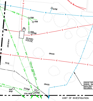
QL‑B Utility Locates using EM, GPR, and surface feature correlation
-
Structure Scanning: Optional LiDAR for manholes, catch basins, and vaults
-
Aerial Photo Documentation with GPS tagging
-
CAD-Ready Outputs for integration with your site survey
-
Quality Level Labelling (QL‑B, QL‑A) in line with ASCE 38-22
-
Coordination Support with surveyors, engineers, and design teams
-
We support your team from field locate to CAD-ready delivery.
-
We’re Not Surveyors – We’re Underground Specialists
We don’t do boundary or elevation surveys—but we work alongside your surveyor to fill in the most overlooked layer: what’s below ground. Whether you need a one-time locate or an ongoing partner, our team ensures you’re designing with the full picture.
Start Smarter. Build Safer.
Whether you're planning a new development, retrofitting an existing site, or updating infrastructure records—we’ll help you Know Before You Design.
